Showing posts with label White Mountains. Show all posts

Monday, January 8, 2018

Breaking Trail in the Belknaps: Whiteface Mountain

Panoramic view from the summit of Whiteface
This past Sunday the temperatures finally crept around 10ºF (balmy, compared to the negative temps and brutally cold wind chills of the days and weeks before), so I decided to get out my snowshoes and head up to the lakes region of New Hampshire to revisit one of my favorite lesser known summits, Whiteface Mountain in the Belknaps. It is overshadowed in both size and recognition by the New Hampshire 4000-footer of the same name and the well known summit in the Adirondacks, but it provides a great view of the Squam Lake area and the southern Whites from its exposed summit for not too much effort.
I had never made the trek to this mountain in winter before, so I was excited to see how the Whites would look with their snow-capped peaks from the summit. The "bomb cyclone" that roared through the state on Thursday dumped a tremendous amount of fresh snow on the trail, and with it being a lesser-visited summit, I knew I might have to break trail to the summit, yet another first experience for me.
Go as Gumby tells you
I arrived at the parking pullout at the end of Belknap Mountain Road just before 1 p.m. and walked up to the trailhead where it became clear my snowshoes were going to be required. As usual, I saw the big brown "Whiteface Mountain Trail" sign on one of the trees at the start, but just below it was a tinier arrow-shaped "Trail Hike" sign pointing me into the woods. What I loved about it was that a Gumby figure was sitting atop the sign as well, pointing me the same way. I know it may have been someone's that was lost along the trail, but its positioning here was a humorous way to start the trip.

At the very beginning the trail was roughly broken out, most likely by the folks in the house next door to this first section entering the woods. A short ways past their backyard the trail had snowmobile tracks on it from them as well, but quickly the trail turned into untouched powder. It looked like they may have bare-booted a little ways up the trail, but once past the Lakes Region Conservation Trust kiosk, I was breaking fresh snow most of the rest of the trip.

Blue blazes made route finding easy the whole way up
The trail was well-blazed, so there were no issues in keeping track of it even with the fresh snow blanketing the usual path. For the majority of the stretch up to the saddle between Piper and Whiteface mountains, the snow ran about 6-10" deep, making my footsteps feel like I was walking on pillows and waterbeds along the way. I learned quickly that breaking a trail gets the quads working overtime. This made me happy that I had picked a smaller mountain with shorter mileage for this first experience.

As I neared the saddle between the two peaks I ran into my first significant snow drifts of the trip, ranging in depth from about 2-3 ft. It was no fun watching my snowshoes sink into deep, soft snow with all my weight sinking with them. This made the final pitch up to the right turn to continue on the Whiteface Mountain Trail even more difficult than the trail breaking that led up to it.

From the saddle, I turned right to continue on the Whiteface Mountain Trail to the summit of Whiteface. Along this section, the trail ran the whole gamut from a crusty 2-3" to more 2-3 ft. drips. The deepest drifts came right where the trail heads into a small open field before continuing along the ATV route to the summit. Once I crossed the field, I was able to hike along some snowmobile tracks some of the way to the summit, while still breaking trail when the tracks would disappear in the blown over snow from the previous few days.
Snow capped peaks of the White Mountains in the distance
At the summit, the snow was covered in a thin icy crust and not deep at all. There were several snowmobile tracks running along it that had broken the snow pack down to form a path. The view to the north was magnificent, with several snow-capped peaks in the Whites standing out. I enjoyed an hour on the summit all to myself before heading back down. As I had about a half-mile left to get back to the trailhead I ran into the only other hiker I saw that day. He thanked me for breaking trail as he continued to pack down the work I started. The descent from there was wonderful, gliding on my snowshoes on fluffy white snow, smoothing and packing the trail further the whole way down.

The trail was much more enjoyable on the way down!
It was an interesting experience breaking a trail for the first time, one that makes me even more grateful for those folks that do it frequently. It's something I definitely don't have the legs to do on the bigger summits of the Whites, but it was a good to get my first taste of it on this little trip. As always, I can't recommend this lesser-known Whiteface enough. I've visited the summit three times and have never had to share the view with anyone. Happy hiking!

Sunday, December 24, 2017

Christmas Eve Along Smarts Brook

After two days of snow, freezing rain, and all sorts of other wintry precipitation dumped on the state I was itching to get up into the Whites to get in my first snowshoe trek of the year. With only one wintry hike under my belt so far this month, I decided to keep it relatively flat and try out a loop around Smarts Brook in Waterville Valley.

I got to the parking area for Smarts Brook off of NH-49 around 10:30 a.m to find it plowed (but very slick asphalt nonetheless) with two cars there before me. After getting out of my car and strapping on my bright green snowshoes, I headed straight into the forest next to the kiosk at the parking area and took an immediate left onto the Pine Flat XC (cross-country) Ski Trail. It started out nice and flat and mostly well-tracked, not leaving much for me to pack down with my snowshoes. However, the shoes did come in handy as I ventured off trail in many spots all around the loop to get an up close look at winter slowly taking hold of Smarts Brook.

A beautiful scene of marshmallow boulders along Smarts Brook
I came to the first major blow-down on the Pine Flat Trail just past its junction with the Old Waterville Rd. Trail. It was about a 6" diameter tree laying across the trail that was easy to step over. From this point on to the junction with the Yellow Jacket XC Trail, the weight of the prior days' snow made more and more trees sag into the trail, including one more major blow-down with most of its branches left waiting to snag a down jacket and one section of so many trees sagging in such low succession that the best way to tackle them was to plow straight through.

Some previous hikes had given one of the evergreens along the trail some Christmas spirit
At the sign for the Yellow Jacket XC Trail I took a right to head southeast down towards the junction with the Smarts Brook Trail. It was clear that this trail had gotten much less use compared to Pine Flat, as my snowshoes came in handy most of the way along the route, packing down a set or two of footprints that hadn't done much to break out this stretch of trail. However, the snow, with its crusty, crunchy top coat of ice from yesterday's rains, was not deep enough to make the task of packing down the trail too arduous.

Walking along the Yellow Jacket XC Trail
After shooting off trail along the way a couple times to take in some views of the brook, I finally came to and crossed the large wooden bridge that brought me to the Smarts Brook Trail for the final leg of my loop. To my surprise, this was the least tracked out of all the trails I took! It shocked me that the only primary hiking trail I was using had the least amount of usage upon my arrival. Therefore, I was extremely happy to have my snowshoes here as I flattened the path of sunken footsteps along the way.

Up until the final junction of my hike, all the prior intersections had been clearly marked with large signage to point me the right way. As I neared the final half-mile stretch of my hike, I came to a split in the Smarts Brook Trail, with the wider trail most closely resembling what I had been on going to my left and a narrower, but still well-tracked trail delving deeper into the woods to my right. I took the trail to my left first and got a little ways down before I checked my AllTrails app to see that I was walking down Smarts Brook Road at this point instead of Smarts Brook Trail. It was a quick backtrack to the junction I chose wrongly at the first time and then I ducked into the narrower trail in the woods which led me on a nice downhill stroll where I emerged out of the woods a short distance from the parking area, with a nice view of Welch and Dickey Mountains in the distance.

Welch and Dickey in the distance as I completed my hike
In all this was a wonderful hike to get back into the swing of snowshoeing. The few ascents I had were never steep, with most of the hike being nothing more than a nice stroll in the woods, breaking trail along the way. This loop is probably one I'll visiting again one spring when the snow has thawed and the brook is roaring, a several cascades along the way looked like they would be quite wonderful to see that time of year.

Sunday, October 29, 2017

Exploring the Cardigan Subpeaks


Taking in Mt. Cardigan a different way
Mount Cardigan gets a lot of love, as well it should, for the dramatic views from its bare, windy summit. I hadn't been up that way in a couple years, and with the nice forecast for Saturday, I decided to return. When I arrived at the parking area on the west side of the mountain it was packed as I expected, with cars streaming down the road into every nook and cranny to create a spot. When I got out of my car and realized just how crowded it was, with several large groups getting ready to head up, I decided to change my route for the day, skip the big draw of Cardigan's summit, and make a loop to check out three of its subpeaks instead: Rimrock, Orange Mountain (Gilman Mountain), and the South Peak. This plan ended up giving me exactly what I wanted, a longer day on the trails, and dramatic views all to myself from three peaks that I argue rival the draw of Cardigan itself.

The 6-mile loop I created for myself involved 6 trails all around Cardigan, so rather than trying to write it out in as thorough a story form as possible, I'm going to break this hike down by trail and summit, bullet pointing the highlights of each section; so, without further ado, let me begin where I...um...began:

West Ridge Trail (orange blazes, 0.5 mi, 14 min.)

  • A moderate half mile climb to to junction with the South Ridge Trail
  • Trail was still soggy most of the way from the rains on Wednesday and Thursday, with long stretches of mud, some standing water, small puddles, and slick leaves, but no deep sections of mud cake to sink into
Up to Rimrock

South Ridge Trail (orange blazes, 0.7 mi., 33 min.)
  •  The first short portion up onto the South Ridge trail was tough to follow, but after finding a set of rocks looking like stairs, the first blazes appeared and it was smooth sailing from there.
  • Started as a moderate climb for the majority of the 0.7 miles to the Rimrock summit
  • Longer stretches of wet leaves, standing water, and mushy footing here as compared to the West Ridge Trail
  • A steep, slick, rocky switchback section requiring extra care with my footing led to the final drier ridge walk to the Rimrock summit
Panoramic view from Rimrock summit
Trail junction sign on summit. Mount Gilman is the direction for Orange Mtn (same peak)

Scenic view of Orange Mountain (dark hump furthest left) as the descent began over the ridge in the foreground

Skyland Trail (Rimrock to Orange Mtn., white blazes, 1.1 mi., 44 min.)
  • Unlike sections of this trail further south, this portion between Rimrock and Orange Mountain was well-blazed and the foot path was easy to see and follow the whole way.
  • Dramatic, scenic, steep descent to start over more smooth ridges (would have been treacherous if they were still wet from the rains, but thankfully this section was dry) with a view of Orange Mountain in the foreground 
  • Trail then dipped into a long forested col, with softer, easier footing and electric green moss bordering both sides of the trail
  • From the col it was a moderate short climb up to the ledges of Orange Mountain, with the views of Mount Cardigan getting progressively better until my favorite spot of the trip, a large open ledge just below the summit with 180º views stretching from Cardigan to Newfound Lake
Typical forest floor along much of the Skyland Trail
Looking back at first peek of Cardigan summit heading up to Orange Mountain ledges
Panoramic view from large ledge just below the summit of Orange Mountain
Vistamont Trail (yellow blazes, 1.0 mi., 43 min.)
  • Another descent down a smooth rocky ridge to start. However, this one was still wet from the rains the previous few days, making the footing iffy in spots
  • Once in the forest again and below the conifers, the footing became even slipperier as the trail was completely covered in wet fallen leaves. Luckily, I could still make out the path along the forest floor and the trees were well blazed all the way down as well. Slipping every couple steps on a pile of leaves, however, was not the most enjoyable part of the hike.
Trail sign at the top of the Vistamont Trail
View from one of the ridges while descending the Vistamont Trail

A thick blanket of leaves covering the Vistamont Trail

An unnamed brook in full force that I crossed shortly before reaching the Clark Trail junction

Trail sign at Clark Trail junction. It was straight ahead from the viewpoint of this photo to head up the Clark Trail
Clark Trail (yellow blazes, 0.7 mi., 27 min.)
  • Nothing on the trail junction sign noted I had met up with the Clark Trail, but I knew from my map that it was 0.7 miles from the Grand Junction noted on the sign; so I knew it was the correct spot to turn back uphill
  • This section of the trail was still covered in leaves, but much drier as it was being hit by the sun the whole way up, making for a much easier ascent compared to the slipping and sliding down the Vistamont Trail.
  • The trail did become wetter and muddier as it neared PJ's Ledge.
  • Trail was well blazed and signed up to PJ's Ledge, where I then took a left to go onto the Hurricane Gap Trail.
View from PJ's Ledge

Hurricane Gap Trail  (0.4 min. to South Peak, 15 min.)

  • 1st half of this trail just past the AMC High Cabin was some of the wettest of the day, with large slippery rocks, large puddles, and small streams running on the trail
  • After about halfway the trail turned to much drier footing on a soft forest floor with more rich green moss bordering the edges like the Skyland Trail until it met up with the South Ridge Trail
AMC High Cabin along the Hurricane Gap Trail

South Ridge Trail to South Peak
  • A short climb up a dry rocky ridge to the best view of the approaches to the Cardigan summit and the firetower (and loads of people) at the top
View of Mount Cardigan from South Peak cairn
Panoramic view to the southeast from the South Peak. Orange Mountain is at center, with Rimrock at the right edge.
From South Peak it was another descent along a rocky ridge back down to Rimrock where I decided to take the Skyland Trail over to its junction with the West Ridge Trail for my descent, rather than trying to navigate the wet, rocky switchbacks of the South Ridge Trail I had gone up in the morning. The first half mile of my descent down this portion of the West Ridge Trail was particularly damp, muddy, slippery on its rockier stretches.

As I said at the start, I got to enjoy the views from these three peaks all to myself, as I saw dozens and dozens of folks heading up to the main Cardigan summit while resting at each peak. The loop I took was an enjoyable challenge, climbing and descending multiple peaks in a day while traversing rocky ridges and rich forest floors. It really couldn't have ended up being a much better day out on the trails, and I highly recommend this loop to anyone wanting to experience the Mount Cardigan area in a little different way.

Get out there and explore!

Monday, October 16, 2017

Peaked Hill Pond: A Hidden Gem in the Whites

Small on crowds, big on serenity
On the last day of our anniversary trip in the Whites, my wife and I decided to do a hike that was on the road literally right next to where we staying at the Valley Brook Cottages in Thornton: Peaked Hill Pond. This little known trail is usually looked over by everyone skimming a map of the White Mountains, as it is out of the way of all the other main hiking areas in the notches. However, as we learned after our hike, if you happen to be in the area, this is one that's well worth the trip.

The trailhead was at the end of the aptly named Peaked Hill Pond Road. Since we were in an AWD SUV we were able to drive all the way to the metal gate that marks the start of the trail and park on the left-hand side. There was a parking area a little before where we parked for cars that can't handle the sandy, rough road at the end. It only adds a short bit to the hike and no real elevation gain at all.

From the gate we there were two paths to take, but thanks to the White Mountain Guide we knew to take the larger, more eroded/collapsed road on the left into the woods. This was the only part of the trail where we had to double check our heading, as the rest of the turns along the way were well marked, either by signs clearly stating "Peaked Hill Pond" with an arrow pointing onward or with diamond-shaped yellow signs with large arrows sending us the right way.

The trail was wide, dry and leaf covered the whole way. Aside from a couple stretches of elevation gain tending to the easy side of moderate, this trail was more of a walk in the woods than a hike. It was mostly flat with good footing the whole way to the pond.

Unnamed waterfall below the trail
After passing the first "Peaked Hill Pond" sign with an arrow, we heard the roar of a brook in the gorge-like area of the forest below us off to our right. Through the trees, we could see what looked like a pretty sizeable waterfall, so we ventured off trail, tumbled down into the rougher stuff, and came upon a magical cascade. There were two side-by-side that looked to be 15-20 ft. tall, making for an awesome off trail discovery. We were even more surprised to not see this waterfall listed in our insanely thorough New England Waterfalls book when we got home. It made us feel like grand explorers, discovering such a spot, haha!

As "Fall in New England" as fall in New England can get
We arrived at the pond to find a serene view of Peaked Hill over its namesake pond. The pond was still, peaceful, and quiet. The hill was at peak autumn color, and with a rich blue sky full of white puffy clouds behind it, it made for a quintessential New England setting. We were actually surprised to see two canoes on the shores when we arrived, which I found later are possibly used by adventure groups that make regular trips out to the pond. Other than that, it was a wonderful natural setting

If you are ever in the Thornton area, or want to find a trip to add on to other adventures to and from the Whites, I highly recommend this hike. It's a simple stroll that'll take you to a place where you can feel miles away from everything else. I can definitely see this being an add-on hike to one of my trips in the future.

Fall in Full Force on Hedgehog Mountain

Greetings from Hedgehog Mountain!
My wife and I had our 5th wedding anniversary this past weekend, and for this year we decided to celebrate it by checking out the fall colors in the White Mountains. After living in New Hampshire for four years, we had yet to even take a hike up there yet during this season, given all we'd heard about how the traffic and crowds could get. Either way, we decided to brave the buses and packed parking areas and set off on a few hikes.

We got up to the mountains Thursday night, giving ourselves a three-day weekend to enjoy as much of the fall colors as we could. Since we knew the crowds would be thin on Friday, we decided to drive down the Kancamagus Highway to hike Hedgehog Mountain. It was listed as one of the best day hikes in two of our guidebooks (Hiking the White Mountains and AMC's Best Day Hikes in the White Mountains), so we thought it was great trip to combine a scenic drive and nice hike. I mean, how can you go wrong with a mountain named Hedgehog!?

When we arrived at the parking area around 12:30 p.m. it was about 75% full. The parking area for Hedgehog Mountain also serves as the start of the trail up Mt. Potash and the Downes Brook Trail, so that didn't surprise us. We passed maybe 5 or 6 groups during our whole hike, which made us think the cars were split pretty evenly among the main hikes of Hedgehog and Potash.

The start up the UNH trail was wide, flat, and easy, a gentle stroll in the autumn woods. After 0.2 miles, I had to double check our White Mountain Guide to make sure we continued the right direction, as the signage at this juncture as to what was the cross-country ski trail and what was the hiking trail was little confusing. A quick read reassured us to turn right and we were on our way. From here, the rest of the junctions were clearly marked to make the loop around the UNH Trail easy to follow.

After 0.8 miles, we arrived at the loop junction and decided to follow it clockwise as was recommended by all three books we'd referenced. From here, we finally started to gain elevation at a steady, moderate clip over your traditional New Hampshire rooted, rocky trails. The colors of fall were in full force, with vivid yellows, oranges, and reds in the leaves on the trees and on the ground. There were a few short steep pitches mixed in along the way to really get our lungs and legs going as we headed toward the first views of the day.

Fall in full panoramic splendor from the east ledges
My wife taking in the view from the ledges
Stepping out onto the first ledges on the east side of the mountain, we were overjoyed with the foliage and peaks stretching out before us. The deep reds and oranges of the trees losing their leaves were in stark contrast to the rich dark greens of the conifers holding strong in the higher elevation, creating quite the colorful landscape. By our recollection, these ledges had the best views of the day, and would be worth a trip all to themselves. However, with the full loop in mind, we continued onward for the summit.

Headed into the forest to reach the summit seen at center
From the east ledges it was quick drop back into the forest, followed by a steep climb up some rocky switchbacks to the high point of the mountain. We were thankful for very dry trail conditions, as a day of rain beforehand would have made some of these steep, smooth rocks very difficult to manage.

View near the summit
The view from the summit was basically a different perspective of our first views of the day on the ledges below, along with some views out to the west. We stayed there for a while to eat a late lunch before heading down to complete the loop. The descent off the summit was almost as steep and rough as the climb we'd just done, but more rooted and worn as opposed to smooth and rocky.

View from Allen's Ledge
Just before completing the loop we made the quick side trip to Allen's Ledge. This side trail was clearly marked with a sign, and it was a quick (read steep and rooted) climb to the viewpoint. More fall colors stretched out before us here making both sides of the loop worth the journey.

Hedgehog Mountain was as awesome as a mountain with such a name should be. It mixed in great views with a good variety of hiking over roots and rocks with varying levels of elevation gain to make for a well-rounded hike. As mentioned before, the highlight of the trip was definitely the first set of ledges. I could definitely see taking a hike just to that point and back when you want a quicker trip in the area. Overall, it was a great start to a fall weekend in the Whites.

Monday, September 18, 2017

Early Fall at Lonesome Lake

A fine afternoon in the Whites
With the New England Patriots playing at one in the afternoon on Sunday (keep the crowds at home, haha!) and a very sunny forecast for the mountains, I figured what better time for the pup and I to head up to one of my favorite spots in the Whites, Lonesome Lake?

The most obvious, popular route to the lake and AMC hut that sits just above its shores is the Lonesome Lake Trail from the Lincoln Woods campground along I-93. However, with my plans not getting me on the trail until 2:30 p.m., I knew that that parking lot, as it usually is on weekends, would be packed with cars spilling out into every nook and cranny of space along both sides of the interstate. Therefore, I decided to take what I consider a much more scenic and enjoyable route starting at the Basin pull-off just south of the campground.

The Basin itself is usually busy as it was that afternoon with people stopping to take in the wonderful cascades and waterfalls along the short walking trails in the area, but few venture further into the part of the Basin that I find the most rewarding: The Basin Cascade Trail. It's one of my favorite trails I've hiked in the Whites. Not long after starting this trail that my pup and I were away from the main tourist section and walking up alongside the Cascade Brook, which actually starts at Lonesome Lake. The ascent on this trail was dry, moderate and gradual, but full of plenty of exposed roots and rocks along the way to keep me vigilant about each step.

Early view from the slabs along the Basin Cascade Trail
As always, what I loved most about this trail was just how close we were to the brook the entire time. There are several spots along the beginning where you can walk right out onto open rock slabs with the brook tumbling down beside you as you stare back at some beautiful views of mountain peaks back towards the notch. From there, the brook dipped into a small gorge below us that is home to Kinsman Falls. Past this first waterfall, the brook was right at our side again as we made an easy crossing of it. From here, the second half of the trail was slicker and muddier compared to the start, but continued a moderate climb up to the second major waterfall along the way, Rocky Glen Falls

Kinsman Falls
Rocky Glen Falls
Just past Rocky Glen Falls was the trickiest section of the hike, the second major stream crossing to take the Cascade Brook Trail up to the lake. There was once a bridge just south of where we crossed that made this crossing a piece of cake that has long been washed away. It looks like there a no plans to ever rebuild it, but the water was running low enough this day to make the rock hop across very manageable. Be advised that in higher water, this crossing can be a bit precarious.

Early section of the Cascade Brook Trail
The Cascade Brook Trail, also a portion of the Appalachian Trail, started mostly flat and much less rooted and rocky compared to the Basin Cascade Trail. There was very little elevation gain up until the junction with the trail leading up to the Kinsman Pond shelter and Kinsman Ridge. From there, the trail began its steady, moderate to moderately difficult ascent to the lake. What was a flat easy trail transformed into a mangled, rocky climb. It was never as tough as climbing boulders on the Presidentials, but compared to the rest of this hike it was the most difficult stretch. However, the reward was certainly worth it...

The Franconia Ridge
Lonesome Lake was peaceful and serene upon our arrival. We only saw one other family and one or two other solo hikers the entire time we were there. The nosiest thing in the area were the ducks quacking at each other in the water. The skies were clear with just enough clouds to paint a beautiful scene above the view of the Franconia Ridge.

The hike packed a one-two combination of great view gained by way of a great set of trails. It is a less used route to the lake, but one I consider much more enjoyable for the extra mileage and more gradual ascent compared to the Lonesome Lake Trail. It's a trip I highly recommend if you have yet to check it out.

Enjoying the early fall colors on the way back down the Basin Cascade Trail
Here are the time breakdowns from my hike:
  • Start at the Basin parking area - 2:10 p.m.
  • Junction with the Cascade Brook Trail - 2:51 p.m. (1.3 total miles)
  • Arrive at Lonesome Lake - 3:37 p.m. (2.7 total miles)
  • Left Lonesome Lake - 4:06 p.m.
  • Junction with the Basin Cascade Trail - 4:42 p.m.
  • Back at the Basin parking area - 5:45 p.m.

Sunday, September 10, 2017

Hiking the Moose

The views stretched for...feet today...
It had been a couple weeks since I had taken my pup on a hike, so I knew he would primed and ready for a big day. I decided to take him to one of my favorite peaks in New Hampshire and what would be his biggest mountain to date, Mt. Moosilauke. Having hiked it via the Gorge Brook Trail at the start of my quest to tackle the NH 4000 Footers back in 2014, I wanted to try a different route to the top, so I decided upon the approach from the Glencliff Trail to add in the South Peak summit I had yet to visit.

We started a little after 8 a.m. up the Glencliff Trail parking area. This is same route northbound AT hikers take as they head into the heart of the White Mountains. The beginning conditions were as good as I could ask for on such a well-used path. For the first mile and a half the trail was almost completely dry with easy, soft footing and only a spare root or rock jutting out of the ground here or there. The grade at the start was mostly moderate with a few steep pitches that made my pup and I have to catch our breath before continuing.

At about 1.5 miles in we reached a couple brook crossings that then gave way to a wetter, muddier, rockier, and..."rootier?" (we'll go with it) trail. In several spots the footing was squishy at best, and it seemed that every rock and root on the ground had just enough moisture on it to make every step a slippery decision. The stretches of soft ground from earlier had given way to a relentless battle of stepping on, over, and in between all these obstacles that were to be our trail for most of the rest of the way up. Even as we reached a long stretch of little elevation gain, having to meticulously plan each step subbed in as a new annoyance.

About 2.5 miles in we reached the stretch of trail known as "The Agony," (knowledge nugget from Stephen D. Smith's NH 4000 Footer Guide) and we quickly learned how well-deserved that name was. This half mile full-on ascent was a rocky rampart with little relief along the way. It was the steepest stretch of trail the whole day, composed mostly of large rocks and boulders. It was like climbing a collapsed, jagged staircase from a not-so-funhouse. We were happy to leave it behind once we reached the junction with the Moosilauke Carriage Road 3.0 miles into the hike.

Up in the alpine zone
At this junction there is also the short spur trail to the South Peak, but I decided to save that for our return trip back down. Therefore, it was up into the alpine zone and onto the main Moosilauke summit. Up to this point it had been a mostly sunny hike, but during this 0.9-mile stretch the clouds and wind descended upon us, limiting our visibility to only 100 ft. or so in front of us. I made sure my pup stayed in close range ahead of me as the scrub trees gave way to the completely bare home stretch to the summit sign. This section of the trail was a relief after "the Agony" with only about 300 ft. of elevation left to gain over that 0.9-mile run. It was still muddy even in it's flat stretches, but the rockier portions of this trail were dry and easy to navigate. Being an old carriage road, it was weird to see such wide sections of trail so high up in the Whites!

New highest summit for this guy!
The summit was a blustery blanket of clouds which my pup enjoyed much more than me. We only spent enough time for me to snap a picture of my furry friend on his new highest summit hiked before we headed back into the scrub trees for some relief from the wind.

I appreciated the orange trail signs on a day like today
Before heading back down the Glencliff Trail, we took the 0.2-mile spur path over to the South Peak summit. This trail started as a soft, damp stretch of mud before entering a quick, steep, rocky push to the top. It was a very tight single-track ascent, made ever more enjoyable by another calamity of rocky steps forming the climb while conifer branches snatched at me and my trekking poles.

We had a little more luck with views at the South Peak, with a few distant mountains briefly poking in and out of the clouds rolling by us. My camera sadly deleted the pictures I took of these peaks, but know that the views here were better than its higher counterpart.

A wee bit blustery on the South Peak. I had to keep my hat from flying into the valley below!
After taking in the South Peak for about 20 minutes we headed back down towards our car. Having dealt with so many stretches of soggy trail, the descent was just as rough as the climb to start the day. At this point, the bottom of my hiking shoes were more mud than tread, making for slippery steps on roots and rocks the whole way down. I was happy to reach the dry, soft trails we started the day with to give my feet and knees a break as we trekked towards the parking lot.

Some nice limited views on the home stretch
Minus losing the photos I took and the lack of views from the main summit, it was good day up in the Whites. When we got back home, my pup was ready to head outside again, so apparently 8 miles of hiking and 3300 ft. of elevation gain wasn't enough to wear him out! Having now taking the Glencliff and Gorge Brook Trail to the top, I definitely prefer the Gorge Brook for its more moderate ascent. The next time I head up to tackle the Moose, I bet I'll be taking that one again.

Here are the time breakdowns for our hike:
  • Start at Glencliff Trail parking area - 8:05 a.m.
  • Junction with Moosilauke Carriage Road - 10:18 a.m. (3.0 total miles)
  • Moosilauke summit -  10:50 a.m. (3.9 total miles)
  • South Peak summit - 11:25 a.m. (5.0 total miles)
  • Left South Peak summit - 11:45 a.m.
  • Back at Glencliff Trail parking area - 1:41 p.m. (8.2 total miles)

Tuesday, September 5, 2017

An Epic Day in the Clouds: Tackling the Bonds

Sometimes the views don't make the adventure. That was certainly the case for my brothers and I as we set out on a 15.4 mi. trek on Sunday to knock out four official NH 4000 Footers (Zealand, Bond, Bondcliff, and West Bond) as well as Mt. Guyot.

Our journey started from the Zealand Falls Hut where we had arrived the night before for a two-night stay after hiking in over Mt. Hale. During breakfast, we were anxious to hear the latest weather report from the Mt. Washington Observatory to see how bad the outlook was for the day. We knew from checking forecasts prior to hiking into the land of no cell service that Sunday was looking sketchy with some moderate to heavy rain and strong winds expected. We were happy to hear the hut croo say that the heaviest of the rain wasn't expected until the evening. We decided we had the window of opportunity we needed to get in all the peaks, so we finished up breakfast and set off from the hut around 8 a.m.

We could see the clouds starting to thicken in the sky as we stepped out of the hut and took in one of the few good views of the day. The sun was still showing through and cast a wonderful light on the first signs of fall down in the valley. From there, we began the steep trek up the Twinway Trail. Going in this direction, we were headed southbound on the Appalachian Trail and gaining a lot of elevation over not a lot of mileage. We passed several thru-hikers headed for Crawford Notch along the way. It was a steep, (dry) rocky climb for most of the way until we came to the crest of the Zealand ridge and headed for the Zeacliff viewpoint. We got there just in time to take in our last view of the day with the White Mountains stretching out all around us and the clouds gathering with ever increasing speed.

Our best view of the day from Zeacliff
From the viewpoint we continued on the Twinway Trail along the ridge now gaining elevation at a much gentler pace. The trail had smooth easy footing by way of bog bridges, smooth rock faces and single track dirt runs for a good portion of this section before becoming increasingly steeper and rockier as we headed up to the side trail for the summit of Zealand.

It was at this point that the winds also picked up as well, causing us all to add an extra layer to battle the gusts that would be bothering us for the rest of our trip. The clouds also descended upon us as well and became part of our path the rest of the way out and back.

Ladder heading up the Twinway Trail to Zealand (Photo credit: Paul Vinson)
The final climb up to Zealand was probably the easiest ascent of the day, both because of its gradual elevation gain and it was the point our legs were at their freshest. The side trail to the summit was well marked with a small cairn and a sign on a tree pointing us the right way. Going the direction we were headed you can't miss it. We quickly headed over to the summit to bag peak number one for the day, and then it was on to Guyot.

From the summit of Zealand the trek picked up in strenuousness as it was a steep drop off the summit followed by a steep climb up to Guyot, almost like hiking along the letter "V." There were points along this section we had to get on all fours to clamber up rock slabs and keep our balance along sections of the trail that were just rocks piled on more rocks.

When we broke the treeline at the Guyot summit, we were finally hit with our first truly strong gusts and wet weather of the day. As we turned left to head down the rough, rocky start of the Bondcliff Trail, we were bombarded by winds so strong that we couldn't hear each other without shouting even when standing side-by-side. We couldn't tell if the water smacking us was rain or just the moisture in the clouds whipping by, but either way, we would be getting damp the rest of the way.

Once we got back into the trees the descent was quick down past the Guyot campsite and trailhead for West Bond (we decided to save that for our return route). The climb up to our high point of the day, the summit of Mt. Bond, was a gradual rocky approach, now a little slippery with rain starting to fall. The winds on the summit of Bond were stiff and made our stay up there brief. The mix of the wind and rain made the chills set in quickly whenever we took a respite above treeline, so we tried to save most of breaks for warmer, more wooded sections of the trail.

My older brother, Paul, descending Mt. Bond onto the Bondcliff ridge
Once over Bond we steeply descended onto the Bondcliff ridge, coming out of the trees onto a very slippery, rocky welcome to full exposure. Everything on the ridge was well soaked from the rain and winds. We had to keep our tired minds focused on following the cairns and finding good footing, but we all slipped and stumbled a few times. Luckily, none of us got any injuries along the way.

My brothers working their way along the ridge
The thick cloud cover hid the iconic cliff of the Bondcliff summit well, and we falsely hoped we had reached the summit several times, only to see another, higher section of the ridge appear before us. After three or four false summits, we were finally rewarded with a view of the cliff on our right and climbed up onto the summit to cap the furthest point of our adventure.

This is as close as we were getting to the cliff with those winds! (Photo credit: Paul Vinson)
 On our way back to the Zealand Falls Hut, all of our trails were now soaked and sopping wet. The side trip to West Bond was a quick twenty minutes each way, and the winds on its exposed summit were probably the harshest we felt during the entire trek. We trudged over slippery boulders, thick mud, deep puddles, and ever increasing rain until we finally returned to our starting point at the hut, ducking under the porch just as the clouds really let loose a downpour. All told we completed this hike in 15.4 unbelievable miles in 9 hours and 45 minutes, crossing the 5 mountains along the way a total of 9 times. We arrived back at the hut a mere 15 minutes before dinner service, soaked from head to toe.

With the mix of the terrain and the weather, this was the most challenging hike I've taken on in my quest to summit all of the 4000 footers, and I am so happy my brothers were part of this chapter. I wouldn't have picked this day to hike these mountains solo, but the three of us now have an amazing story of unbelievable accomplishment we will most certainly look back on every time we get together.
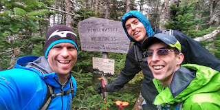
Photo credit: Paul Vinson